4-Day Northern Parks Extension — Tanzania
The less-visited but extraordinarily rewarding northern reaches of Tanzania’s legendary safari circuit — a landscape of volcanic highlands, remote wilderness, and wildlife experiences that complement and deepen everything the classic Serengeti-Ngorongoro combination offers, reaching into corners of northern Tanzania that most visitors never find.
The Northern Extension — Why It Matters
Tanzania’s northern safari circuit is one of the most celebrated wildlife destinations on earth — the Serengeti, Ngorongoro, Tarangire, and Lake Manyara forming a sequence of extraordinary parks that together constitute arguably the finest concentration of wildlife experiences available anywhere. But the northern extension — the parks, conservation areas, and wilderness landscapes that lie beyond and between these famous destinations, reaching toward the Kenyan border and the remote volcanic highlands of the Kilimanjaro and Meru massifs — adds a dimension of depth, remoteness, and ecological diversity that the classic circuit cannot fully provide. Amboseli ecosystem influences, the remote wilderness of Lewa and the borderlands, the volcanic drama of Ol Doinyo Lengai and Lake Natron, the rarely visited Arusha National Park and the Monduli highlands — these northern extensions transform a standard northern Tanzania safari into something considerably more complete and considerably more personal. Four days in the northern extension is structured around destinations and experiences that most Tanzania visitors miss entirely and that those who find them consistently describe as among the finest wildlife and landscape encounters of their entire African experience.
Day 1 — Arusha National Park & Kilimanjaro Views
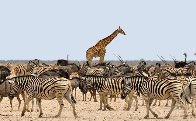
Morning — Into Arusha National Park Arusha National Park — sitting immediately northeast of Arusha town between Mount Meru and the Kenyan border — is one of Tanzania’s most consistently underestimated and most frequently skipped national parks, its modest size and proximity to the safari circuit’s major destinations making it seem like an appetiser rather than a destination in its own right. This assessment is comprehensively wrong, and the morning of day one spent properly in Arusha National Park is sufficient to demonstrate why. The park covers 542 square kilometres of extraordinary ecological diversity — from the montane forest on Mount Meru’s lower slopes, through the open grassland and acacia woodland of the Ngurdoto Crater area, to the flamingo-frequented waters of the Momella Lakes chain that sits at the park’s eastern boundary with the Kilimanjaro massif rising magnificently on the eastern horizon. The approach to the park from Arusha town passes through a landscape of coffee and banana cultivation that gives way abruptly at the park boundary to dense montane forest — the transition from agricultural Uganda to wild Tanzania happening in the space of a few metres with the particular dramatic completeness that national park boundaries sometimes achieve. Within the forest, black-and-white colobus monkeys move through the canopy in troops of extraordinary size — the Arusha National Park population is one of the most accessible and most reliably encountered in Tanzania, the animals habituated to vehicle presence and observable at close range with a frequency that dedicated primate destinations cannot always match. Olive baboons, blue monkeys, and the occasional red-tailed monkey complete a primate community of considerable richness within a park that most Tanzania itineraries allocate no time to at all.
Mid-Morning — Ngurdoto Crater The Ngurdoto Crater — nicknamed the Little Ngorongoro for the obvious reason that it is a smaller volcanic caldera sharing the fundamental structure of its famous southern neighbour — is one of the park’s most atmospherically distinctive features. Unlike Ngorongoro, Ngurdoto is accessible only from its rim — the crater floor is a protected wilderness zone into which no vehicle or visitor may descend, preserving it as a genuinely undisturbed sanctuary whose wildlife lives in complete freedom from human intrusion. Viewing the crater floor from the elevated rim positions — the forest-clad crater walls dropping steeply to the open floor where buffalo, warthog, and various antelope graze in the morning light — carries a particular quality of observation that the inaccessibility creates and that the fully accessible Ngorongoro cannot quite replicate. The rim viewpoints are positioned at different compass points around the crater, each providing a different perspective on the floor below and different conditions for bird watching in the forest edge — the Hartlaub’s turaco, the silvery-cheeked hornbill, and various forest sunbirds moving through the canopy at the crater rim level while the crater floor wildlife goes about its business far below in complete unawareness of the watching faces above.
Afternoon — Momella Lakes & Canoeing The Momella Lakes — a chain of seven shallow alkaline lakes in the park’s eastern sector, each with slightly different mineral composition producing different colours and supporting different concentrations and species of waterbird — are one of Arusha National Park’s finest features and one of the most unjustly overlooked birding destinations in northern Tanzania. The lakes’ alkalinity supports the algal blooms that attract lesser flamingos in their thousands during peak season, the pink shimmer of the flocks visible from considerable distance across the flat water surface. Greater flamingos work the slightly deeper margins in smaller numbers. Pelican colonies nest on the lake islands. And the open water supports an impressive diversity of duck, grebe, and wading species whose combined presence makes the Momella Lakes one of the finest waterbird viewing sites in the northern circuit. A canoe safari on the largest of the Momella Lakes — gliding silently through the flamingo flocks at water level, the birds parting unhurriedly before the bow and closing behind the stern — provides a perspective on the lake’s bird life that no land-based observation point can replicate. The paddling is gentle, the guide managing the canoe’s approach to the flamingo concentrations with the practiced patience of someone who knows exactly how close the birds will tolerate before flushing and whose skill lies in maintaining that precise distance while providing the visitor with the closest possible views.
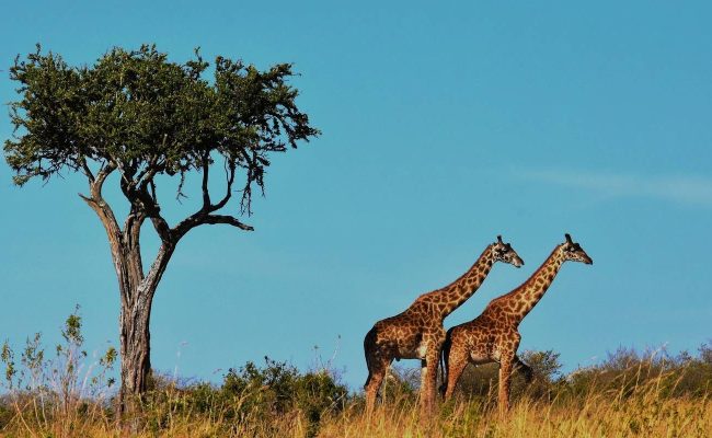
Sunset — Kilimanjaro Reveal The finest single view available from Arusha National Park — arguably one of the finest views in Tanzania — is the prospect from the Momella Lakes area eastward toward Kilimanjaro on a clear afternoon, the mountain’s glaciated summit rising above the eastern horizon in the late afternoon light with the particular luminosity that snow-capped peaks acquire in the horizontal illumination of the hours before sunset. Kilimanjaro from the Momella Lakes is seen across the open grassland of the park’s eastern sector, giraffes and zebras moving in the foreground, the mountain filling the sky behind them in a composition of such classical African beauty that it appears slightly too perfect to be real. The lodge serving this sector of the itinerary — Momella Game Lodge, the oldest lodge in the park and the location where portions of the film Hatari were shot with John Wayne in the early 1960s — sits within the park boundary with direct views of both Kilimanjaro and Mount Meru, its history and its position combining to create one of the most atmospherically distinctive lodges in northern Tanzania.
Day 2 — Ol Doinyo Lengai & Lake Natron
Pre-Dawn — Drive to the Rift Valley The journey from the Arusha area south and west toward Lake Natron and Ol Doinyo Lengai descends from the highland landscape of the northern circuit into the floor of the Great Rift Valley — a geological descent of dramatic proportions that is accompanied by equally dramatic changes in landscape, vegetation, and atmosphere. The road drops from the well-watered highland plateau through a series of escarpment switchbacks that reveal the Rift Valley floor opening below in progressive stages — each hairpin bend exposing another thousand metres of descent, another layer of geological time in the escarpment face, and an increasingly arid and increasingly extraordinary landscape spreading toward the distant volcanic peaks of the Rift’s eastern wall. By the time the road reaches the Rift Valley floor the landscape has transformed completely — red volcanic dust replacing the highland red laterite, the vegetation reduced to sparse acacia and dry scrub, the heat intensifying dramatically, and the sense of having descended into a different world — older, more elemental, more indifferent to human presence — asserting itself with considerable force.
Morning — Ol Doinyo Lengai Ol Doinyo Lengai — the Mountain of God in the Maasai language — is one of Africa’s most extraordinary geological features and one of the world’s most unusual active volcanoes. Rising 2,962 metres from the Rift Valley floor in a near-perfect cone of dark volcanic rock, Lengai is unique among the world’s active volcanoes in erupting natrocarbonatite lava — the only volcano on earth to produce this specific lava type, which is so low in temperature relative to conventional basaltic lava that it appears black rather than red when it flows, and which reacts with atmospheric moisture to turn brilliant white within hours of eruption, giving the volcano’s slopes and crater a ghostly pale appearance quite unlike any other volcanic landscape. The volcano has been in a state of near-continuous low-level activity since 2007 — minor eruptions, gas venting, and lava flow from the summit crater are regular occurrences — making it a living, breathing geological feature whose activity can be directly observed from the surrounding landscape. The standard full summit climb — beginning at midnight for a dawn arrival at the crater — is a serious mountaineering undertaking requiring fitness, equipment, and guided expertise. The northern extension itinerary includes a partial ascent or circumnavigation at the volcano’s lower slopes — sufficient to experience the extraordinary lunar landscape of the volcanic terrain, the views across the Rift Valley floor to Lake Natron below, and the geological interpretation that makes the volcano comprehensible rather than merely visually impressive — without the physical commitment of the full summit attempt.
Afternoon — Lake Natron Lake Natron is one of Africa’s most extreme and most visually surreal environments — a vast shallow soda lake fed by hot springs and seasonal rivers in the rain shadow of Ol Doinyo Lengai, whose surface temperature can reach 60 degrees Celsius and whose pH approaches 10.5, making it one of the most caustic bodies of water on earth. The lake’s extreme alkalinity — the result of the natron mineral deposits that give it its name, produced by the same volcanic activity that built Lengai — is lethal to most vertebrates, calcifying animal tissue on contact with a speed that has produced the extraordinary images of calcified birds and bats that have made Lake Natron internationally known. And yet in this apparently inhospitable environment — precisely because of the extreme conditions that keep predators away — the lake supports one of the world’s most important flamingo breeding colonies. Roughly 75 percent of the world’s lesser flamingo population breeds at Lake Natron in good years, the alkaline mudflats of the lake’s centre providing nesting conditions found nowhere else in East Africa. The pink mass of the breeding colony — visible from the lake’s shore as a shimmering distant mass against the extraordinary red and orange mineral colours of the lake surface — is one of the most improbable and most magnificent wildlife spectacles in Tanzania. The lake’s colours themselves — the red and orange of the mineral deposits, the white of the natron crusts, the deep blue of the sky reflected in the occasional areas of open water — create a landscape palette of such extreme and unlikely beauty that the photographic results consistently appear oversaturated regardless of processing.
Evening — Maasai Community & Rift Valley Camp The accommodation options near Lake Natron are basic by the standards of the classic northern circuit — small tented camps and simple lodges whose facilities are modest but whose position in one of Tanzania’s most dramatic and least visited landscapes more than compensates for the absence of the luxury amenities that the Serengeti or Ngorongoro lodges provide. The evening in the Rift Valley camp — the temperature finally relenting as the sun drops behind the western escarpment, Ol Doinyo Lengai silhouetted against the darkening sky, the lake below turning from orange to deep red to grey in the failing light — is an evening of extraordinary atmospheric completeness. A visit to the nearest Maasai community adds the human dimension that the geological and wildlife experiences of the day have so far addressed only in passing — the Maasai pastoralists of the Natron basin have inhabited this extreme landscape for centuries, their cattle culture adapted to the specific challenges of the Rift Valley’s heat, aridity, and mineral-laden water in ways that represent an extraordinary accumulated ecological knowledge of one of the world’s most challenging human habitats.
Day 3 — Loliondo & Remote Northern Serengeti Border
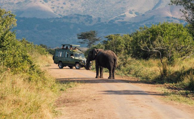
Morning — Loliondo Game Controlled Area The Loliondo Game Controlled Area — the vast wilderness block that borders the Serengeti National Park’s northeastern edge and extends toward the Kenyan border — is one of northern Tanzania’s great wildlife secrets, a community-managed conservation area of over 4,000 square kilometres that supports wildlife populations of extraordinary density within a landscape that very few visitors ever enter. Loliondo is not a national park — it is a multiple-use area in which the Maasai communities who own and inhabit the land have developed wildlife tourism as a compatible land use alongside traditional pastoralism, with several exclusive-use concessions whose operators pay community fees that fund local development while maintaining wildlife populations at levels comparable to the adjacent national park. The wildlife of Loliondo is the Serengeti’s wildlife — the great migration herds move freely across the Loliondo boundary with the national park, predator territories extend across the same invisible boundary, and the ecosystem recognises no distinction between the protected national park and the community-managed concession. What Loliondo adds to the Serengeti experience is exclusivity — game drives conducted in enormous wilderness areas shared by a handful of vehicles rather than the concentrations that the famous Serengeti crossing sites can attract — and the Maasai cultural dimension that the national park itself, by its nature as a protected area from which human settlement is excluded, cannot provide.
Mid-Morning — Oldoinyo Sambu & Border Landscapes The landscape of northern Loliondo — approaching the Kenyan border through the Oldoinyo Sambu highlands — is among the most dramatic in the broader Serengeti ecosystem, the flat-topped acacia plains of the central Serengeti giving way to a more topographically varied terrain of rocky hills, seasonal rivers, and open highland grassland that supports its own distinctive wildlife community. Greater kudu — the magnificent spiral-horned antelope that is among Africa’s most beautiful mammals — inhabits the rocky hillsides of the Loliondo highlands in a population rarely encountered within the national park boundaries. Gerenuk — the extraordinary long-necked antelope that feeds standing upright on its hind legs to reach vegetation inaccessible to other browsers — reaches the northwestern limit of its range in this borderland area. Fringe-eared oryx — the East African subspecies of the oryx, its long straight horns and distinctive facial markings giving it an aristocratic quality unmatched among the region’s antelope — moves across the open highland grassland in small groups. And above the highland scrub, the raptor diversity of the Loliondo borderlands — augur buzzard, bateleur, various eagle species — provides a birding dimension of considerable quality that the wide-open visibility of the highland terrain makes more accessible than the denser woodland of the valley areas.
Afternoon — Kleins Gate & Eastern Serengeti Entering the Serengeti National Park through Klein’s Gate — the remote northeastern entrance used almost exclusively by the Loliondo concession operators and the visitors staying in the handful of camps in the park’s northeastern sector — provides access to the most remote and least visited section of the Serengeti ecosystem and one of its finest for wildlife quality and experience exclusivity. The northeastern Serengeti — the area around Klein’s Camp and the Lamai Wedge — is the part of the park where the great Mara River crossings of the northern migration are most dramatic and most reliably witnessed during the July to October window, and where the permanent presence of the migration herds in the broader area produces year-round wildlife concentrations of extraordinary density. The afternoon game drive through the eastern Serengeti from Klein’s Gate southwest toward the Lobo area covers terrain that in a full day sees a fraction of the vehicle traffic of the central Seronera — the wildlife undisturbed, the sightings uncontested, and the landscape experienced with the particular quality of genuine wilderness that crowd-free safari always delivers and that the most famous parts of the most famous parks can struggle to provide.
Evening — Remote Camp Under Serengeti Stars The camps serving the northeastern Serengeti and Loliondo — Klein’s Camp, Sayari Camp in the northern Serengeti, and the exclusive-use Loliondo concession properties — combine the remoteness and exclusivity of their positions with accommodation and service of genuine quality, their small guest numbers and enormous surrounding wilderness creating the atmosphere of a private safari that the larger central Serengeti properties cannot replicate. The evening game drive extending into dusk — the predators becoming active as the light fails, the hyena clans beginning their nightly circuits, the nightjars settling on the warm track surface — precedes dinner under the Serengeti sky, the Milky Way overhead in a darkness uncompromised by any artificial light source within many kilometres in any direction.
Day 4 — Northern Serengeti & Lamai Wedge
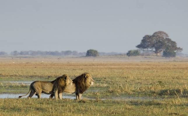
Dawn — Mara River Area & Migration The final morning of the northern extension is devoted to the Mara River area — the stretch of the Serengeti’s northern sector where the famous river crossings of the great migration occur and where the permanent wildlife of the north Serengeti is concentrated in greatest density. The Mara River in the northern Serengeti is a different river from the wider, better-known Kenyan sections of the Masai Mara — narrower, more intimate, the crossing points fewer and more easily monitored by a guide with knowledge of current animal movements and concentrations. In the crossing season — roughly July through October — the morning game drive in the Mara River area combines the possibility of witnessing a crossing with the certainty of extraordinary concentrations of the attendant wildlife — the enormous Nile crocodiles that wait in the crossing pools, the lion prides that follow the migration herds to the river, the cheetah coalitions hunting the open plains between the river crossings, and the vast herds themselves, their numbers and their movement transforming the landscape into something that feels genuinely prehistoric in its scale and its force.
Mid-Morning — Lamai Wedge & Final Game Drive The Lamai Wedge — the triangular section of Serengeti between the Mara River and the Kenyan border — is the most remote and most exclusive game viewing area in the northern Serengeti, its access controlled by the handful of camps whose concession boundaries define the wedge’s southern limit. A final morning game drive through the Lamai Wedge — the landscape of rocky outcrops and open grassland that defines this corner of the Serengeti, the Maasai Mara visible across the river on the Kenyan side — closes the four-day northern extension with wildlife and landscape experiences of genuine distinction. The rocky outcrops — kopjes of the northern type, lower and more scattered than the famous Moru Kopjes of the central Serengeti but equally productive as lion and leopard resting and hunting terrain — are searched with the focused attention of the final morning, each one approached with the anticipation that the extension’s accumulated wildlife experience has sharpened into something between expertise and instinct.
Afternoon — Return to Arusha & Departure The return to Arusha from the northern Serengeti follows one of several possible routes depending on road conditions, timing, and the specific accommodation arrangements of the final night — either by road through the Serengeti and Ngorongoro Conservation Area in a long but extraordinarily scenic drive that passes through the heart of the northern circuit’s most famous landscapes, or by light aircraft from the nearest Serengeti airstrip to Arusha’s Kilimanjaro International Airport, the flight providing one final aerial perspective on the landscape that four days of ground-level encounter has made intimately and permanently familiar. The northern circuit from the air — the Serengeti’s grass plains extending to every horizon, Ngorongoro’s crater visible as a perfect circular depression in the highland plateau, the volcanoes of the Rift Valley edge marking the landscape’s geological spine — is the most comprehensive single view available of a safari landscape whose scale defeats any ground-level attempt at comprehension and whose beauty, from 3,000 metres, looks precisely as extraordinary as it is.
Practical Notes
Best Season for the northern extension varies by specific destination. The Ol Doinyo Lengai and Lake Natron circuit is accessible year-round but most comfortable in the dry seasons of June through October and January through February — the Rift Valley heat is most extreme from November through March and the Natron basin roads can become impassable in heavy rains. The northern Serengeti and Loliondo are best from July through October for the Mara River crossings and from December through March for the calving season that concentrates predators in the southern Serengeti and drives the migration cycle that eventually brings the herds north. Arusha National Park and the Momella Lakes are excellent year-round with the wet season months of April and November producing the finest bird diversity.
Combining with the Classic Circuit — the northern extension is designed to complement rather than replace the standard northern circuit, adding depth and remoteness to an itinerary that already includes Tarangire, Lake Manyara, Serengeti, and Ngorongoro. The four-day extension works best positioned either at the beginning of a longer Tanzania safari — using Arusha National Park and Ol Doinyo Lengai as an atmospheric entry into the country’s northern wilderness before the classic parks — or at the end, using the northern Serengeti and Loliondo as a remote and exclusive finale to a circuit that the famous parks have introduced at a more accessible level.
Specialist Operators with genuine northern extension expertise — including knowledge of the Loliondo concession operators, the Lake Natron and Ol Doinyo Lengai logistics, and the remote northern Serengeti camp options — are essential for maximising the quality and the safety of this itinerary. The northern extension’s logistical complexity, particularly the Rift Valley components, rewards the expertise of operators who work this terrain regularly over those who include it as an occasional add-on to standard circuit programmes.
Photography across the northern extension offers several of Tanzania’s finest subjects — the flamingo concentrations and extraordinary mineral colours of Lake Natron, the volcanic drama of Ol Doinyo Lengai against the Rift Valley sky, the Kilimanjaro views from Arusha National Park at dawn and dusk, and the migration crossing drama of the northern Serengeti all reward serious photographic engagement and produce images with a character and a rarity that the more photographed central circuit locations cannot easily match.
 Email us bookings@twijaafrica.com
 Call us +256 777 559835